Understanding Google My Business & Local Search
Google Earth Add Hi Res Images from Tehran
Google Lat Long Blog announced the availability of hi res images from Tehran, Iran for use in Google Earth:
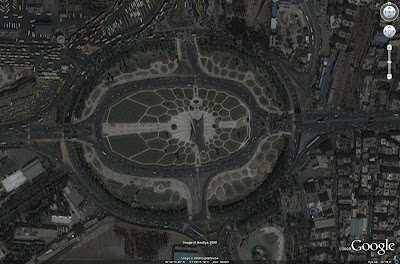
Many of you have been letting us know through Tweets, emails, blog posts, message boards, and even an online petition that you’re very interested in seeing recent satellite imagery of Tehran. Well, we’ve heard your requests and over the past few days have been working with our satellite imagery partner GeoEye to make this possible. We just received updated satellite imagery of Tehran, taken on Thursday the 18th at approximatly 11:18am local time. Below are some screenshots the updated imagery, you can view the entire image in Google Earth with this KML file.

The images above were taken from GeoEye’s IKONOS satellite, which images at roughly 1-meter per pixel. We are continuing to work with GeoEye to see if we can provide a higher resolution update from the GeoEye-1 satellite, which would be at 0.5-meters per pixel, but this is subject to weather constraints. We’d like to thank GeoEye for making this imagery available to us and to thank our users for their advocacy.
© Copyright 2024 - MIKE BLUMENTHAL, ALL RIGHT RESERVED.

Comments
Comments are disabled for this post