Understanding Google My Business & Local Search
When Will Google Fix My StreetView Image?
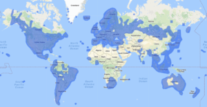
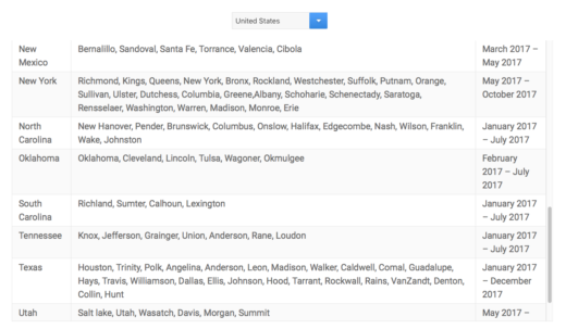
 This falls into the “learn something new everyday in local” category…. fellow Top Contributor Treebles (a more knowledgeable Google Mapping/MyBusiness expert you will not find) advised me that Google publishes their Streetview update schedule for the year and it includes details as to which countries, states and cities they will be visiting.
Who knew? You probably did, but I didn’t.
This question comes up frequently in the GMB forums and elsewhere so its good to know that there is a published schedule.

Although one wonders how does Google decide what the schedule is? Is it based on volume of user reports or date of last visit? Or some algo that just spits out the locations? Probably the latter. 🙂
© Copyright 2025 - MIKE BLUMENTHAL, ALL RIGHT RESERVED.
Comments
10 Comments
At the Tokyo Street View Summit, held May 10-11, new classes of camera certifications were announced. Street View auto ready is one of the new classes. In short this means that you will not have to wait for the Google car to visit to update Street View. All that will be required is the hardware.
According to Google (Charles Armstrong), all connected photosphere will soon appear as the blue line, that currently shows where Street View exists in Google Maps. (Individual photospheres are a blue dot, and deprecated Street View Trusted is represented by the orange dot) .
Street View auto ready
These specs detail all hardware, timing, and data requirements for advanced, vehicle/bike-mountable 360 cameras that intend to offer high-speed, high-accuracy Street View capture and publishing capabilities. These cameras can be controlled via the Street View app.
https://developers.google.com/streetview/ready/specs-auto
@Christopher
Fascinating. Are there companies that are planning or do StreetView imagery for profit? How do they sell it over what Google does for free? Is in typically unique geographies that Google wouldn’t get to (i.e. for tourism) or some other application?
all connected photosphere will soon appear as the blue line, that currently shows where Street View exists in Google Maps. (Individual photospheres are a blue dot, and deprecated Street View Trusted is represented by the orange dot) .
Can you show me an example URL of this occurring?
Hi @Mike
At the IVRPA conference in Vienna a couple of weeks after the Tokyo summit, Stafford Marqardt explain the same thing.
Google plans to reward companies and individuals by replacing the cash “profit” with the opportunity of advertisement. So in the black hole at the bottom of the image which is the area that would be filled by the car roof or the helmet of the person capturing the images, Google will allow to image creator to add their contact details, company name, logo, etc.
The map will maintain all the data, old and new imagery but will show by default the latest using the time machine bar. A question was raised about the possibility of “street wars” 🙂 where a company would drive around a popular area to update the map and next day another would do the same to have their version appear first… This question was not really answered.
The whole talk is here: https://www.youtube.com/watch?v=in8n4qAB5Is&t=530s start at 12th minute more or less.
MY STREET VIEW IS ANCIENT. MY HOUSE NO LONGER LOOKS LIKE IT DID 6 YRS AGO WHEN I MOVED IN. I THINK THE PICTURE IS FROM 2011. I LIVE IN THE 17601 ZIP CODE. I HOPE A NEW PICTURE WILL APPEAR SOON. THANKS
Such a wealth of information Mike. Really helpful for communicating with clients that do have some issues with streetview images that don’t do their business any justice. Helpful links Thanks a bunch.
Hi Shane
It helped me so I figure that there might be a few others like me.
Hi Mike – Big fan of the site down here in Miami!!
One of our clients we were consulting for local seo completely revamped the outside of the building but the Google StreetView was outdated, I believe 2013/4 or so, in a very very small market.
We asked our in-house Google360 partner and she mentioned that there is no way to get Google to come out a specific location.
One of the things they base it on is the number of requests of people asking for updates or new requests in an area consisting of several cities.
360Tip – If you don’t like your current Google360 that is on Google Maps, you can download the Google Street View and with your Smartphone or 360Cam you can take a 360photo and upload it to Street View – There is an option to push that 360Photo to Google Maps and it will be shown above the current Street View.
Your 360 will more than likely a photo of your business inside vs the StreetView which is outside.
You could possibly test a 360 to replicate the StreetView and may likely push the original one down. *Note – If someone clicks on the street view from a Local search it will show the original Street View.
@lenny are there any requirements to get that new streetview accepted?
Great resource, thanks Mike – they are scheduled to be in my city April to Nov 2017 – yaaaay! 🙂
Although all of the above doesnt show little NZ. Can’t wait for our street to be updated, then perhaps my photo wont appear of me going to cross the road. Wasn’t excited to be told this
Comments for this post are closed.